Recent and On-Going JRI Research Programs
Rio Tularosa Prehistory & History: Creekside Village
David H. Greenwald
At Creekside Village, Jornada Research Institute has been focused on the excavations of Feature 11, a pithouse. In the southern half of the structure, including two bell-shaped storage pits, both over 1 m deep and nearly the same in diameter have been excavated. Samples have been collected for botanical analyses to determine what was contained within them. Excavations of the NW quarter of the structure have produced considerable information on the construction elements of the house. As can be seen in the photograph, a series of post holes has been found just inside the pit wall of the structure. These post holes, plus burned reeds from this same area, suggest that an interior wall was constructed in wattle-fashion that provided a covering or separation from the original pit wall, perhaps to retard dirt and gravels from falling into the structure and provide a wall that could be comfortably leaned against. We have also found undulating construction materials that may represent an adobe plaster that once covered the lattice work of the wattle wall, which if it was covered, would have provided even greater comfort to the occupants. Near the exterior ground surface, we have found a ring of post holes that are spaced approximately 50 cm apart.
These post holes probably represent posts that were used as part of the roof structure. Some of the post holes are angled (rather than being vertical) suggesting they “leaned” towards the center of the pithouse. We have identified two main support posts in the floor of the pithouse, which indicates that the roof may have been of a gabled design, with a single cross beam extending between the two main posts. The posts set around the exterior, based on their angled alignments, would have rested against the cross beam. In appearance, the roof may have been shaped like a gabled or hip-shaped roof with a northeast/southwest ridge crest, providing the greatest floor-to-ceiling height through the central portion of the structure. This pithouse is exceptionally large for Mesilla phase structures, with its greatest width 7.2 m (nearly 38 sq m of floor space) as compared to other Mesilla phase pithouses that are generally less than 3 m in diameter (or less than 7 sq m). The structure is D-shaped, with the flat side on the southeast side; its orientation, therefore, closely aligns to the winter solstice rise.
Other floor features include a hearth , a large ash-filled pit (fine, sorted ash probably used in preparation of corn dishes known as “nixtamalization”), secondary post holes, and other small pits of unknown function. Feature 11 has produced a number of shell jewelry items, including items made of abalone, glycymerus, and olivella, plus abalone shell debitage, which indicates production within this house or nearby. Turquoise pendent fragments and stone disk beads have also been found, along with a variety of mineral specimens. It may too early to name this structure the “House of the Jeweler” but evidence is apparent that jewelry production was undertaken as one activity in the house.


Hot Spots
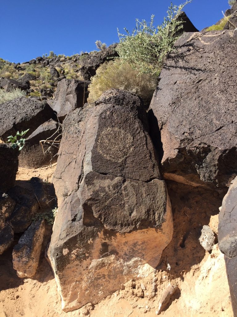
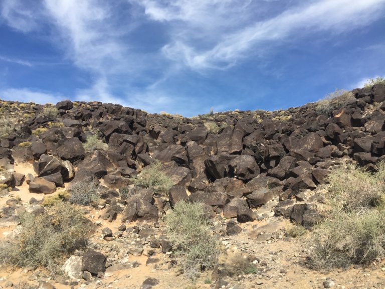
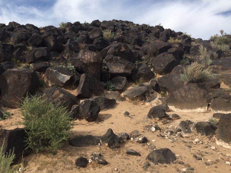
Within each canyon are areas where higher concentrations of petroglyphs occur. These are referred to as “hot spots,” that is, places that appear to reflect higher levels of ritual energy. These photos illustrate hotspots from Piedras Marcadas Canyon.
Petroglyph National Monument
Dr. Jeffery R. Hanson
Fluteplayer Study
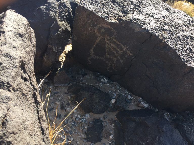
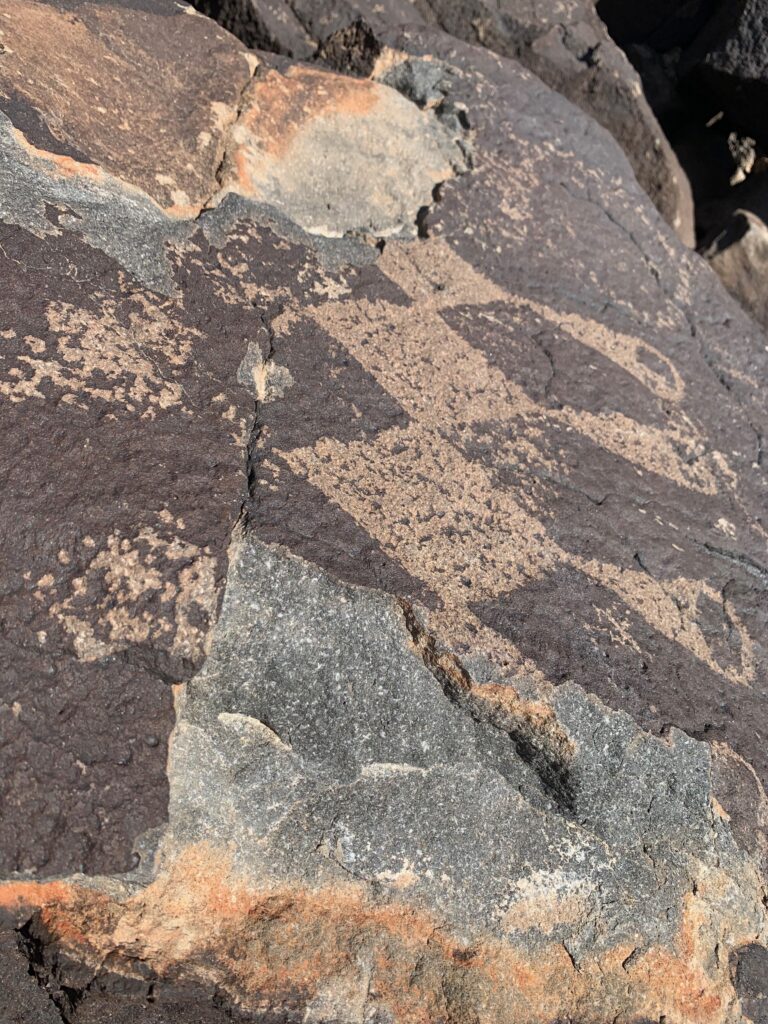
JRI Research Associate Jeffery Hanson has recently completed a survey project at Petroglyph National Monument (PNM). The purpose of the study was to analyze the distribution of the flute player motif in a landscape setting. The flute player, also known as kokopelli, has a wide distribution at petroglyph and pictograph sites in the American Southwest. The motif has been interpreted as a symbol of water and fertility, and is often associated with water/fertility symbols such as serpents, spirals and frogs. The study took a landscape approach to the flute player. The theory was that the motif would be more likely to be found in topographic settings where water might have been available, either seasonally or after heavy rains. We would expect then to find flute players and other fertility symbols on workable rock faces near drainages, seeps, or springs. The escarpment on the west side of Albuquerque provides an excellent landscape setting to test this idea. The cliff faces from north to south are cut by numerous large and small arroyos that would have acted as runoff drainages during times of heavy precipitation, such as during the monsoon season. These drainages could have produced temporary pools or alluvial runoff that would enhance hunting or collection of wild plants.
Placement of the flute players and associated motifs would demonstrate a connection to these localities as places of water, life and fertility. During times of drought, these places might have attracted ritual use as points of communication between shamans and the spirits governing rainfall. In addition these places may have served an ethno-topographic function as a preferred drainage as a water source. Initial observation at the Piedras Marcadas section of PNM has found flute players located in boulder configurations at four drainages. Surveys along the escarpment of Piedras Marcadas Canyon, Boca Negra Canyon, and Rinconada Canyon are being undertaken to document the location of flute players, such as those in these photos.
Results
The survey resulted in the identification of 229 petroglyphs. Of these, 37 (16%) were fluteplayers, 73 (32%) were birds, 58 (25%) were snakes or serpents, 22 (10%) were spirals, and 20 (9%) were turtles or frogs (Figure 17). In addition, 19 boulder metates were identified. With respect to the distribution of these motifs near or along drainages in all cases, with the exception of spirals, expectations were met, albeit some more likely than others. Figure 17compares the overall distribution of motifs with those identified along arroyos. As can be seen, more than any other motif, fluteplayers were concentrated along arroyos, with 33 of 37 (89%) of those identified located along arroyos. Although the other motifs had tendencies in this direction, their association with arroyos was less likely (over 50%), spirals, however, were the least likely to meet predicted expectations. It has to be stressed that the sample here cannot be said to be representative of the broader petroglyph population throughout the canyons, it is clear that within this sample fluteplayers are closely tied to areas where seasonal water could have been available, due to mesa runoff, moisture retention by boulders and flow along arroyos, to nourish wild plants, attract game, and potentially be diverted for agricultural fields. The number of water control features that have been recorded within these canyons supports this interpretation.
Condition Assessment Study
In the fall of 2021 and continuing to the present, Dr. Hanson has been conducting a condition assessment survey of a sample of petroglyphs at PNM. The purpose of the survey is to record natural and human-caused damage to panels within units of the Monument and to provide the Park Service with baseline condition assessment data that can be used to develop monitoring strategies. Thus far, 515 panels have been examined in Piedras Maracas, Boca Negra and Rinconada Canyons, and Mesa Prieta. Of these, 273 (53%) have experienced some form of human damage in the forms of bullet scars (non-recent target shooting), scratching, graffiti, and attempted image removal through chiseling. Three hundred and sixty-nine panels (72%) have experienced some form of natural damage, mostly through cracking and spalling. Other units within the monument are currently being surveyed. The project will continue until the end of 2023.